The 5 best walks in Lanzarote

Lanzarote, the volcanic island of the Canaries, is famous for its unique landscapes, marked by a series of eruptions that took place in the 18th century. These lunar panoramas, which look like something out of a science fiction film, are open to all visitors, but they are best discovered on a hike. You can wander between the black rocks of the sea of lava to discover a pretty abandoned beach where the waves of the Atlantic run aground, or the immense crater of a volcano. You can't help but feel very small next to these natural monsters that seem to have watched over the island for centuries. But don't panic, they've long been extinct. So strap on your hiking boots and your rucksack, and let us show you the 5 best hikes on Lanzarote!

© CCat82 / Shutterstock
Lanzarote

✈️ Book your plane ticket to Lanzarote

Fly to Lanzarote, where nature, culture and art come together in the most charming of combinations!
From
£36 RT
Find my flight

1. La Caldera Blanca

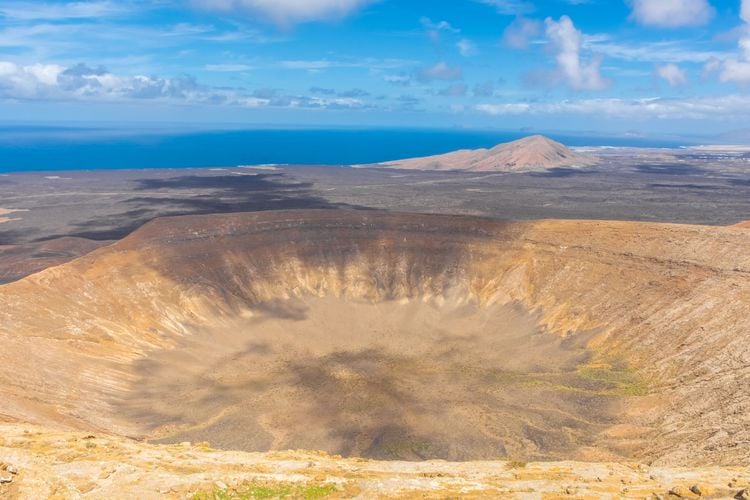
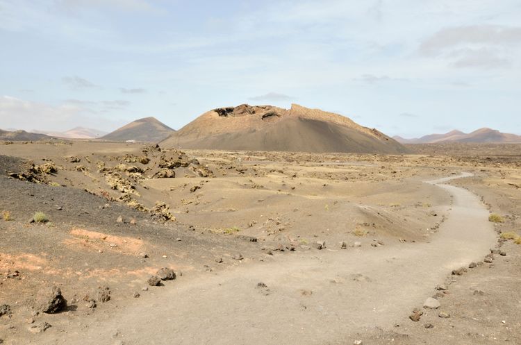
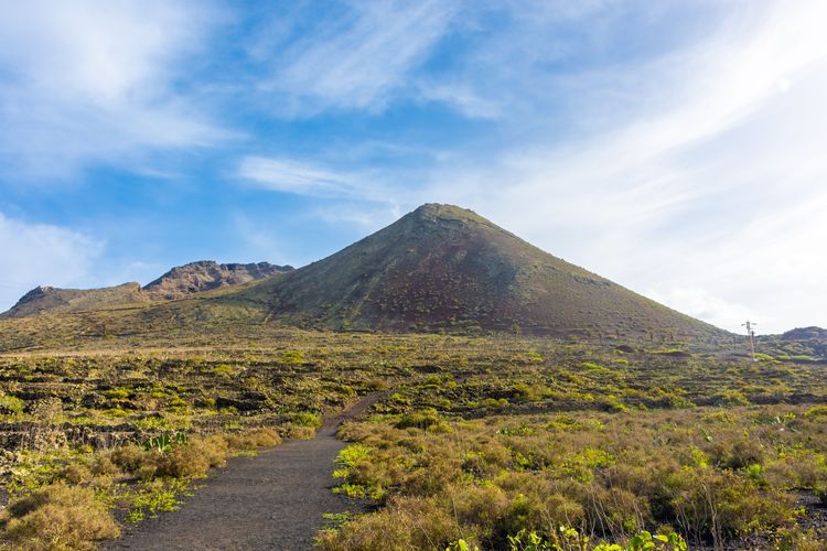
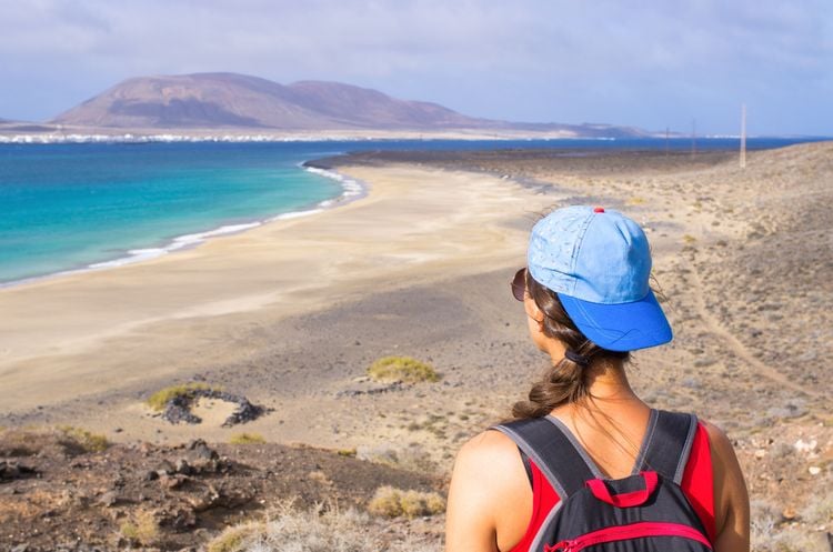
⛰️ Difficulty: medium (9.33 km - 327 m - ↘328 m)

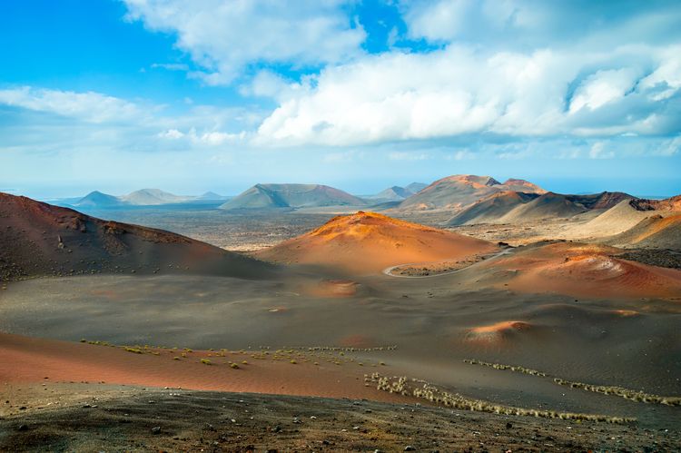
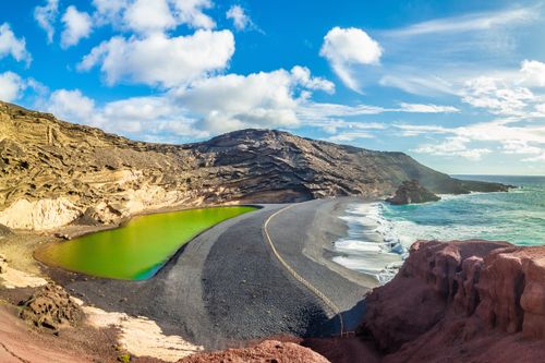
The Caldera Blanca is the largest crater on the Canary Islands. Over a kilometre in diameter, it was created in a single eruption! So it's easy to see why its ascent isone of Lanzarote's must-do hikes.

The route begins at the car park in the village of Macha Blanca and plunges two kilometres into the sea of lava before reaching the Caldereta, Caldera Blanca's little sister with its crater 300 metres in diameter. You then go round the volcano to the right before tackling the ascent: it's a challenging climb, but don't be afraid to take a break - the view of Timanfaya National Park and the ocean is already magnificent!

View of the crater from the summit of Caldera Blanca.

- © Stefano Zaccaria / Shutterstock

The highlight comes once you reach the top: theimmense crater of the Caldera Blanca opens up before you, with the Malpaís and the Atlantic as far as the eye can see. The sheer size of the crater is staggering, and it's hard to imagine that a 'simple' volcanic eruption could have left this behind! You can walk around it to see it from every angle, but beware of the wind, which can make you lose your balance. The path down is opposite the Caldereta, and we then have to turn back to reach the car park.

⭐ Where to stay near the Caldera Blanca?

Finca Curbelo - Uga Lanzarote
Booking.com

Finca Curbelo - Uga

At the start of the wine route, not far from Timanfaya National Park, this traditional finca offers visitors a swimming pool and comfortable rooms.
9.3
From
£132 / night
Book

2. The coastal path at El Golfo

⛰️ Difficulty: easy (7.48 km - 102 m - ↘102 m)

The small fishing village of El Golfo feels like the end of the world. This is even truer when you set off along the coastal path. The route starts at the car park at the far end of the village and plunges into the lava sea without leaving the shore. You can admire the Atlantic waves crashing against the volcanic rock, leaving behind only a spray of foam.

After just over two kilometres, our route takes a right turn, but we decide to take a short diversions to the black-sand beach of del Paso, on the left. There's not a cat in sight - it's like Brigitte Bardot's La Madrague! Be careful, though, as swimming is prohibited here because of the currents.

Playa del Paso on Lanzarote's coastal path.

- © Vesna Kriznar / Shutterstock

We rejoin the main path, which now heads inland towards Montaña Quemada. The path goes all the way round the volcano, but we advise you to make a little extra effort to climb to the top. It's a bit strenuous but very quick, and the view of the ocean and Timanfaya national park will be your reward! Now it's time to head back to El Golfo. We advise you to do this walk in the morning, as you'll meet very few hikers and you can then have lunch in the village, facing the sea: after the effort, the comfort!

⭐ Where to stay in El Golfo?

El Hotelito Del Golfo El Golfo
Booking.com

El Hotelito Del Golfo

In the heart of the fishing village of El Golfo, this hotel with swimming pool offers comfortable rooms, some with sea views!
8.7
From
£80 / night
Book

3. La Caldera de los Cuervos

⛰️ Difficulty: very easy (4.16 km - 58 m - ↘60 m)

If you're more of a walker than a hiker, you don't have to climb a mountain to enter a volcano's crater. The Caldera de los Cuervos trail, which can be walked by almost anyone, takes walkers to the heart of a crater in just under an hour and a half, with almost no change in altitude.

The route begins at the car park, and information panels are scattered along the way to tell visitors all about the environment that surrounds them: sea of lava, volcanic bombs, crater, pyroclasts, etc. They tell us that this volcano was the first to become active during the series of eruptions in the 18th century.

The road leading to Caldera de los Cuervos.

- © Gigi Peis / Shutterstock

The path takes us directly inside the crater, the size of which gives us an idea of the violence of the eruptions that shook Lanzarote so many centuries ago. The route then skirts around the volcano to the right, giving us a chance to admire its full range of colours, but we can also turn around to cut the walk short and head straight back to the car park.

⭐ Where to stay near Caldera de los Cuervos?

Finca Marisa - Tinajo Tinajo
Booking.com

Finca Marisa - Tinajo

A wellness centre, two swimming pools and magnificent rooms await you at the Tinajo resort, not to mention a great breakfast!
9.2
From
£197 / night
Book

4. Playa del Risco on the Camino del Gracioseros

⛰️ Difficulty: medium (8.18 km - 395 m - ↘401 m)

Lanzarote's beaches are superb, but they are often crowded during the high tourist season. We've got the solution! Playa del Risco isone of the island'swildest beaches... but there's a reason for that: a rather strenuous hike of almost three and a half hours awaits those who would like to sample its golden sands.

It all starts at this car park, which leads to a mirador offering a breathtaking view of the beach. For the rest, we hope you have good knees, because we're going to descend 350 metres in a few dozen minutes. The clear, cool waters of the Atlantic greet us at the bottom, a well-deserved reward!

El Risco beach, Lanzarote.

- © Petr Tran / Shutterstock

You can continue as far as the old Salines del Rio, of which not much remains, or return after enjoying the beach. The climb back up is likely to be strenuous, but in the end it's less complicated than the descent. The craziest part of the story is that the inhabitants of La Graciosa used to take this steep path regularly. In fact, before the ferries reached the port of Orzola, the locals used to cross the Río Strait at its narrowest point, landing on the Playa del Risco!

⭐ Where to stay near Playa del Risco?

Casa Nube Blanca - Ye Ye
Booking.com

Casa Nube Blanca - Ye

The sea-view or garden-view rooms in this pretty Ye finca invite you to relax and let go.
9.4
From
£160 / night
Book

5. Monte Corona

⛰️ Difficulty: easy (4.46 km - 151 m - ↘144 m)

The Corona volcano is the origin of the eight-kilometre Atlantis tunnel, parts of which can be seen at the Cueva de los Verdes and the Jameos del Agua, designed by César Manrique. The cascade of lava that flowed from its crater when it first erupted more than 20,000 years ago was more than 400 metres high, leaving behind more than 18 square kilometres of ** *malpaís***. At 609 metres high, it is the largest volcano on Lanzarote, but don't worry, it's not that steep to reach its summit!

Le volcan Monte Corona à Lanzarote.

- © Stefano Zaccaria / Shutterstock

The walk starts at the Ye church car park and winds through vineyards and prickly pear trees towards the Corona volcano. The slope leading to the edge of the crater is fairly gentle, but the path leading down into the interior is quite steep, though rather short, so it's up to you if you make a diversion.

From up here, you can enjoy a privileged view over the whole island and the volcano's crater, whose red colour contrasts with the blue of the sky. However, beware of the wind, which can quickly cause you to lose your balance. We descend along another path that takes us close to the Torrecilla de Domingo castle before returning to our starting point.

A few tips for hiking in Lanzarote

  • Between the sand and the volcanic rocks, we advise you to bring good hiking boots to protect your feet.
  • Don't forget to take plenty of water and sun protection(sunglasses, hat and sun cream).
  • Plan your hike early in the morning to avoid the crowds on the busiest paths.
by Editorial Team
Need a hand? take a look at our guide
Lanzarote
Lanzarote
Further reading
Discovering the Mountains of Fire
Lanzarote
Discovering the Mountains of Fire
Timanfaya National Park is Lanzarote's main attraction. It's a lunar or Martian landscape, but it's so un-Earthly! It's the setting for Journey to the Centre of the Earth, where you...
5 days in a van around Lanzarote
Lanzarote
5 days in a van around Lanzarote
Although camping in the wild is theoretically forbidden in the Canary Islands, the authorities on Lanzarote often turn a blind eye and allow tourists to explore the island's lunar...
Discover the natural attractions of El Golfo
Lanzarote
Discover the natural attractions of El Golfo
The island of Lanzarote is indeed the wildest of the Canaries, with El Golfo, a charming fishing village, being a prime example. Isolated at the end of a winding road, set on the edge...
Latest news
Milan
From Raphael to Caravaggio... the exceptional collections at the Pinacoteca di Brera
Lyon
The Vieux Lyon district: between religious buildings and traboules (narrow streets)
Agadir
Paradise Valley
Geneva
Discover Maison Tavel
Read more articles
Top destinations